New Wayfinding Signs Installed on Lake Link Trail and More to Come!

If you ride, walk, or roll through Broomfield's trail system, you've probably noticed some exciting updates: the Lake Link Trail is now fully equipped with Broomfield's brand-new wayfinding signage! This is the first trail in the city to receive updated signs and pavement markers, with more improvements on the way as part of the larger Broomfield Wayfinding Plan.
This marks a big win for people who Ride Broomfield, making it easier than ever to navigate the city's trails, discover new routes, and arrive at your destination with confidence.
What's New on the Lake Link Trail?
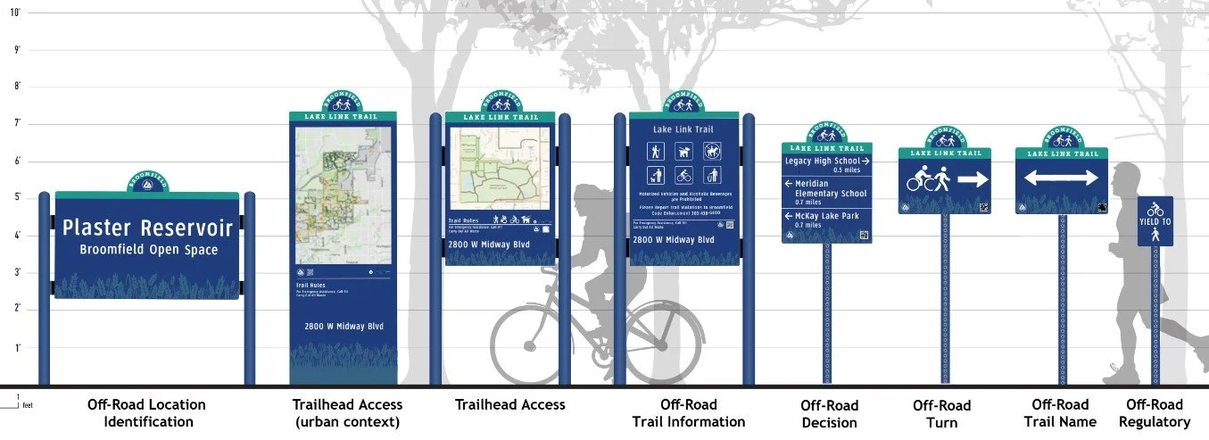
New Vertical Signs: These eye-catching trail signs help you identify your location along the Lake Link Trail and point you toward destinations like nearby parks, neighborhoods, and civic buildings.
Pavement Markers: Reinforcing the signage are new on-the-ground markers that add clear visual cues under your wheels or feet, making route-finding intuitive as you move.
Consistent Design: The signs use a clean, easy-to-read design tailored to meet the city's updated standards, ensuring clarity whether you're traveling by bike, on foot, or another mode.
Why Wayfinding Matters in Broomfield
This new signage is part of a larger vision: making active transportation not only easier but also more enjoyable and accessible. The program was developed in response to community feedback through the Open Space, Parks, Recreation, and Trails (OSPRT) Master Plan and the Broomfield Bicycle and Pedestrian Assessment.
Residents shared clear requests:
"Help me understand where I'm going."
"Show connecting routes with confidence."
"Make our trail and bike networks easier to navigate for everyone."
Broomfield's Wayfinding Plan directly addresses these needs, providing riders and walkers with an easy-to-follow visual system to connect more freely across the city, without relying on their phones or guessing their route.
What Areas Will Be Signed Next?
Lake Link Trail is just the beginning. Wayfinding plans are already in motion for several other high-use corridors, including:
From Broomfield Civic Center to County Commons
From Shep's Crossing to Northmoor Park
Future updates across trails and bikeways that link into regional destinations and local hubs
As signs are installed on more priority routes, you'll be able to seamlessly connect from trail to trail, neighborhood to park, or bus stop to business—all without missing a turn.
How Will This Improve Trail Accessibility?
The new signage improves access in several key ways:
Reduces confusion: With consistent markers and direction signs, people won't get turned around or miss key connections—beneficial for new riders and visitors.
Boosts confidence: Whether commuting by bike, jogging, or using a mobility device, the signs let you know you're on the right track, encouraging more people to choose car-free travel.
Encourages exploration: It invites you to try new trails or routes, now that wayfinding makes navigation easier and more visible.
Overall, this improved wayfinding system enhances the safety, comfort, and accessibility of Broomfield's entire trail network.
When Will More Signs Be Installed?
Good news—more signs are coming soon! The Broomfield Wayfinding Plan includes a multi-phase rollout, with additional routes prioritized based on usage, connectivity, and community input. There is dedicated funding to expand signage over the next several years, so expect to see more updates in parks, along trails, and at critical intersections across Broomfield.
What Can People Who Ride Broomfield Expect Going Forward?
People who Ride Broomfield can look forward to:
Easier, more intuitive navigation across popular trail routes
A growing map of signed and accessible destinations
Clearer connections between neighborhoods, parks, and civic centers
Fewer barriers to getting out and riding—whether for errands, recreation, or daily commutes
The Lake Link upgrades are just the starting point of a larger vision for a connected, user-friendly trail and bikeway system throughout Broomfield.
Stay tuned for updates and keep an eye out for new signs popping up along your favorite routes. The way forward is getting clearer every day for everyone who rides, rolls, or walks in Broomfield.
Broomfield Wayfinding project page: https://www.broomfieldvoice.com/wayfinding
Consider a donation to keep Ride Broomfield Rolling